Here is an example of water table level by zip code (water well depth) we collected by doing the steps below.
| Water Table Level | By Zip Code | By City |
|---|---|---|
| 17.0 feet | 02148 | Essex County, MA |
| 21.8 feet | 01960 | Providence County, MA |
| 28.0 feet | 01360 | Franklin County, MA |
| 50.0 feet | 02536 | Barnstable County, MA |
| 12 feet | 01453 | Worcester County, MA |
Access water table level by zip code (water well depth map)
Step 1 – Access the source page
Link: https://maps.waterdata.usgs.gov/mapper/index.html
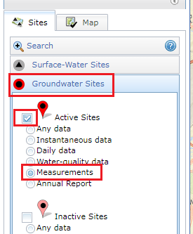
Step 2 – Choose the Data Type
Choose Groundwater Sites -> Active Sites -> Measurements
Step 3 – Move the water well depth map
Move the map around to find your area -> Zoom in to see the nearest red dot in your area
![Water Well Depth Map [Water Table Level By Zip Code]](https://flixwater.com/wp-content/uploads/2022/05/flixwater-water-well-depth-map-water-table-level-by-zip-code-1280x697.jpg)
Step 4 – Access the data
Click on the nearest red dot -> Click Access Data -> Find the water table level of your area

For example:
The well depth level of Norfolk County, Massachusetts is 52.2 feet below the land surface.
